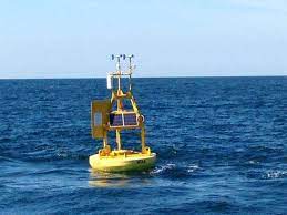
Many Park City locals have been wondering – why did we get such a stellar winter last year… and why is this year so… meh? Some urban legends advise counting what day the moon cycle is in on during the first snow as it supposedly predicts how many snow days there’ll be that winter. Other people rely on the Weather Channel, or perhaps, if you’re like me, you check the morning forecast on perhaps the most basic platform available – the default weather app (yuck). Well, grab your compass and head southwest towards the Pacific Ocean because off the coast of Hawaii is perhaps the best way to predict the season’s snow forecast – the powder buoy.
The “powder buoy” originated with Michael Ruzek and Hank Manninen. It began when Hank (who lives part-time in Hawaii and part-time in PC) suggested to Michael (also a PC local) that a buoy used by the National Oceanic and Atmospheric Administration (NOAA) to track and predict swells might be related to storms along the Wasatch front. Upon further inquiry, Ruzek noticed a correlation between the wave heights predicted by the buoy for the Hawaiin swells and snowstorms in Utah. Ruzek pointed out that this has only occurred when the buoy measured a specific height which he called a “pop” of sorts. Likewise, Ruzek has determined that Powder Buoy technology relates to low-pressure systems (or meteorological patterns) and hypothesizes that when such systems hit the buoy, it triggers the rise in wave height and thus indicates that a storm is brewin’ in Utah.
So next time you’re dying to make a snowman, hit the slopes, or build a snow fort… check out the Powder Buoy. Your glory days may be two weeks away! And perhaps after all the thumb twiddling, Park City will get some real snow.


